Visitor Counter

hitwebcounter web counter
Visitors Since Blog Created in March 2010

Click Below to:

Add Blog to Favorites

Coyotes-Wolves-Cougars.blogspot.com

Grizzly bears, black bears, wolves, coyotes, cougars/ mountain lions,bobcats, wolverines, lynx, foxes, fishers and martens are the suite of carnivores that originally inhabited North America after the Pleistocene extinctions. This site invites research, commentary, point/counterpoint on that suite of native animals (predator and prey) that inhabited The Americas circa 1500-at the initial point of European exploration and subsequent colonization. Landscape ecology, journal accounts of explorers and frontiersmen, genetic evaluations of museum animals, peer reviewed 20th and 21st century research on various aspects of our "Wild America" as well as subjective commentary from expert and layman alike. All of the above being revealed and discussed with the underlying goal of one day seeing our Continent rewilded.....Where big enough swaths of open space exist with connective corridors to other large forest, meadow, mountain, valley, prairie, desert and chaparral wildlands.....Thereby enabling all of our historic fauna, including man, to live in a sustainable and healthy environment. - Blogger Rick

Subscribe via email to get updates

Enter your email address:

Receive New Posting Alerts

(A Maximum of One Alert Per Day)

Wednesday, February 28, 2018

"As readers of this Blog know well, overabundant white-tailed deer populations have serious negative effects on understory plant community structure and composition(biodiversity)"............... "Wolves, which are top predators of deer, have been recolonizing central Wisconsin since the early 1990s. "Two different research studies( U.S. Forest Service-2006, State U. of NY/U. of Wisconsin-2013) have come in with similar findings---Results suggest that seedling survival of preferred, browse- sensitive seedlings is higher in areas continuously occupied by wolf packs(Wolves as top down carnivores enrich biodiversity of surroundings)".............."These results are consistent with hypothesized trophic effects on understorey plant communities triggered by a keystone predator(Wolves) recovering from regional extinction"............. "These studies represent the first published evidence of a trophic cascade triggered by wolf recovery in the Great Lakes region"


Wolf Recovery and the Future of Wisconsin's Forests: A Trophic Link

12/15/16; 
  • US Forest Service Research & Development
  • 1400 Independence Ave., SW
  • Washington, D.C. 20250-0003
  • 800-832-1355

Principal Investigators(s) :
Moser, W. Keith
Research Location : Wisconsin
Research Station : Northern Research Station (NRS)
Year : 2010
Highlight ID : 208


Snapshot : Overabundant white-tailed deer populations have serious negative effects on understory plant community structure and composition. Wolves, which are top predators of deer, have been recolonizing central Wisconsin since the early 1990s. NRS scientist Keith Moser and partners from the University of Georgia are measuring trophic cascade effects, that is, whether wolves are reducing local browse intensity by white-tailed deer and thus mitigating the biotic impoverishment of understory plant communities.

HIGH WOLF DENSITY ZONES IN THE NICOLET NATIONAL FOREST
REVEAL HIGHER DENSITY OF OAK AND RED MAPLE SEEDLINGS
THAN IN LOW DENSITY WOLF ZONES


 Top picture high density understory in hi Wolf density zone
and bottom picture reveals low density understory in low 
Wolf densisty zone


 THE TROPHIC CASCADES, " TOP-DOWN" POSITIVE
INFLUENCE OF WOLVES ON THE ENVIRONMENT


Recolonizing wolves trigger a trophic cascade in Wisconsin (USA)-June 6, 2013

Authors


Photo pair of understorey vegetation within the Chequamegon-Nicolet National Forest, WI. (Top) Shows a high wolf area (within the Bootjack Lake pack territory) and (bottom) shows the paired low wolf area (in the buffer zone between the Bootjack Lake pack and the Miles Lake pack).


Summary


  1. We tested the hypothesis that wolves are reducing local browse intensity by white-tailed deer, thus indirectly mitigating the biotic impoverishment of understorey plant communities in northern Wisconsin.
  2. To assess the potential for such a top-down trophic cascade response, we developed a spatially and temporally explicit model of wolf territory occupancy based on three decades of wolf monitoring data. Using a nested multiscale vegetation survey protocol, we compared the understorey plant communities of northern white cedar wetlands found in high wolf areas with control sites found in low wolf areas.
  3. We fit species–area curves for plant species grouped by vegetation growth form (based on their predicted response to release from herbivory, i.e. tree, seedling, shrub, forb, grass, sedge or fern) and duration of wolf territory occupancy.
  4. As predicted for a trophic cascade response, forb species richness at local scales (10 m2) was significantly higher in high wolf areas (high wolf areas: 10.7 ± 0.9, N = 16, low wolf areas: 7.5 ± 0.9, N = 16, < 0.001), as was shrub species richness (high wolf areas: 4.4 ± 0.4, N = 16, low wolf areas: 3.2 ± 0.5, N = 16, < 0.001). Also as predicted, percentage cover of ferns was lower in high wolf areas (high wolf areas: 6.2 ± 2.1, N = 16, low wolf areas: 11.6 ± 5.3, N = 16, < 0.05).
  5. Beta richness was similar between high and low wolf areas, supporting earlier assumptions that deer herbivory impacts plant species richness primarily at local scales. Sampling at multiple spatial scales revealed that changes in species richness were not consistent across scales nor among vegetation growth forms: forbs showed a stronger response at finer scales (1–100 m2), while shrubs showed a response across relatively broader scales (10–1000 m2).
  6. Synthesis. Our results are consistent with hypothesized trophic effects on understorey plant communities triggered by a keystone predator recovering from regional extinction. In addition, we identified the response variables and spatial scales appropriate for detecting such differences in plant species composition. This study represents the first published evidence of a trophic cascade triggered by wolf recovery in the Great Lakes region.

Tuesday, February 27, 2018

"Throughout history, Indigenous peoples have been responsible for the development of many technologies and have substantially contributed to science.".........."Indigenous perspectives(TRADITIONAL ECOLOGICAL KNOWLEDGE-(TEK) are holistic and founded upon interconnectedness, reciprocity and the utmost respect for nature"................. "For centuries, Indigenous people's lives depended on their knowledge about the environment".......... "Many plant species—including three-fifths of the crops now in cultivation and enjoyed across the globe—were domesticated by Indigenous peoples in North, Central and South America"........... "Corn, squash, beans, potatoes and peppers are just a few examples of foods that now contribute vastly to global cuisine!"............... "Indigenous knowledge about the medicinal properties of plants has been instrumental in pharmacological development"............... "For example, as settlers arrived in North America, Indigenous people helped newcomers cure life-threatening scurvy through conifer-needle tonics that were rich in vitamin C."....................... "The active ingredient in the pain reliever Aspirin, acetylsalicylic acid, was first discovered by Indigenous people who utilized the bark of the willow tree"............... "Medicinal plant properties are still being recognized to this day—especially in tropical ecosystems—as Indigenous people share their knowledge"........."Elders of the Heiltsuk First Nation in B.C. recognized two types of wolves—coastal and inland— previously undocumented by Western scientific methods"........... "With such proven value in only a few examples, imagine how TEK can further inform science!"

https://phys.org/news/2018-01-indigenous-knowledge-advances-modern-science.html

How Indigenous knowledge advances modern science and technology


January 3, 2018 by Jesse Popp

Throughout history, Indigenous peoples have been responsible for the development of many technologies and have substantially contributed to science.


Science is the pursuit of the . Approaches to gathering that knowledge are culturally relative. Indigenous science incorporates traditional knowledge and Indigenous perspectives, while non-Indigenous scientific approaches are commonly recognized as Western science. Together, they contribute substantially to .
Although the value of integrating Indigenous science with Western science has been recognized, we have only begun to scratch the surface of its benefits.
Indigenous perspectives are holistic and founded upon interconnectedness, reciprocity and the utmost respect for nature. Both Western and Indigenous science approaches and perspectives have their strengths and can greatly complement one another.
As an Indigenous scientist who specializes in combining traditional ecological knowledge with wildlife ecology research, I have come across many examples where blending both approaches has resulted in excellent contributions to modern science.
Roots of food and medicine
For centuries, Indigenous people's lives depended on their knowledge about the environment. Many plant species—including three-fifths of the crops now in cultivation and enjoyed across the globe—were domesticated by Indigenous peoples in North, Central and South America. Corn, squash, beans, potatoes and peppers are just a few examples of foods that now contribute vastly to global cuisine!


Indigenous knowledge about the medicinal properties of plants has been instrumental in pharmacological development. For example, as settlers arrived in North America, Indigenous people helped newcomers cure life-threatening scurvy through conifer-needle tonics that were rich in vitamin C.
The active ingredient in the pain reliever Aspirin, acetylsalicylic acid, was first discovered by Indigenous people who utilized the bark of the willow tree. Medicinal plant properties are still being recognized to this day—especially in tropical ecosystems—as Indigenous people share their knowledge
Technology to TEK
Technological innovations such as the canoekayaktoboggan or snowshoe aided in travel and transport and were quickly adapted by European settlers.
Indigenous peoples, with their decades of personal experience combined with that of their ancestors, harbour vast knowledge about the environment and the ecological relationships within them. Tremendous opportunities exist where such knowledge can contribute to modern science and natural resource management.


Indigenous knowledge, also known as Traditional Ecological Knowledge (TEK), is essentially the cumulative body of knowledge associated with ecological relationships, which is handed down through generations by Indigenous people.
TEK has already provided insight into environmental change, wildlife population monitoring, sustainable harvesting practices, behavioural ecology, ecological relationships and so much more.
Inuit observations have identified several important environmental changes in the Arctic as a result of climate change, and their knowledge about bowhead whale behaviour helped researchers revise their survey methods to improve population size estimates.
Elders of the Heiltsuk First Nation in B.C. recognized two types of wolves—coastal and inland— previously undocumented by Western scientific methods. With such proven value in only a few examples, imagine how TEK can further inform science!
TEK continues to compliment Western science. In light of recent moose population decline across North America, my own research aims to incorporate Indigenous knowledge to help identify factors that may be responsible for this decline.
Indigenous education is essential
Despite the recognized value of Indigenous perspectives and knowledge, there are few Indigenous science scholars. Scholars with specialization in Indigenous science can provide mentorship as well as become role models for current and prospective Indigenous science students.
By encouraging Indigenous science scholar recruitment, forthcoming research incorporating Indigenous perspectives can pave the way to promote culturally inclusive scientific approaches.


Many wildlife species are at risk across the planet, and engaging in co-operative management initiatives that embrace Indigenous science are now more important than ever. Collaborations are becoming more and more common. For example, the Canadian government incorporates TEK in assessing species at risk. The Worldwide Indigenous Science Network (WISN) restores TEK dialogue to the world's most pressing ecological issues.
Throughout history, Indigenous people, perspectives, and knowledge have contributed substantially to the development of science and technology and will surely continue to do so for generations to come!
Further reading
Indian Givers: How Native Americans Transformed the World by Jack Weatherford. Broadway Books, 2010.
Indigenous Knowledge, Ecology, and Evolutionary Biology by Raymond Pierotti. Routledge, 2011.
"What tradition teaches: Indigenous knowledge complements western wildlife science" by Paige M. Schmidt and Heather K. Stricker. USDA National Wildlife Research Center – Staff Publications, 2010.
-------------------------------------------------------------------------------------------------------------------

https://www.fws.gov/nativeamerican/pdf/tek-fact-sheet.pdf

Traditional Ecological Knowledge for Application by Service Scientists--United States Fish & Wildife Service(February 2011

Working Definition of Traditional Ecological Knowledge Traditional Ecological Knowledge, also called by other names including Indigenous Knowledge or Native Science, (hereafter, TEK) refers to the evolving knowledge acquired by indigenous and local peoples over hundreds or thousands of years through direct contact with the environment.


This knowledge is specific to a location and includes the relationships between plants, animals, natural phenomena, landscapes and timing of events that are used for lifeways, including but not limited to hunting, fishing, trapping, agriculture, and forestry. TEK is an accumulating body of knowledge, practice, and belief, evolving by adaptive processes and handed down through generations by cultural transmission, about the relationship of living beings (human and non-human) with one another and with the environment.


It encompasses the world view of indigenous people which includes ecology, spirituality, human and animal relationships, and more. The Use of TEK is Nothing New and Continues to Evolve Local biological knowledge, collected and sampled over these early centuries, most likely informed the early development of modern biology. For example, during the 17th century the German born botanist Georg Eberhard Rumphius benefited from local biological knowledge in producing his catalog

Monday, February 26, 2018

Long Island, New York----The final frontier in the continental USA for Coyotes to colonize is increasingly within reach of becoming a reality................."A pair of coyotes was photographed in Middle Village in Queens, NY in December 2016 Nagy et al. (Long Island coyote breeding 905near 40.8801° N, 072.9741° W WGS84)"............. "This sighting is the first report of a pair of coyotes in eastern Long Island" .........Prior to this in 2016, a Coyote pair had pups adjacent to Laguardia Airport in Queens, NY, a "hop, skip and a jump" down the road from Nassau County, Long Island, NY.............."Long Island resembles the eastern forest 'mosaic landscape' with early-successional and mature forests, meadows, and suburban areas that coyotes have success-fully exploited throughout the eastern USA"........... "In particular, the north shore of both Nassau and Suffolk counties have large tracts of protected open space"......... "Farther east, the land use of Suffolk County generally spans a spectrum from suburban to rural, perfect habitat for Eastern Coyotes"..........As for how Coyotes have (and will continue) to enter Long Island, via crossing the heavily traccked bridges(from Queens) or swimming across the Long Island Sound"............."While all of these routes appear challenging to individual coyotes and has likely limited the rate of dispersal to and colonization of Long Island (see Nagy et al. 2016), Americas most opportunistic and highly adaptable canid most likely will in fact make Long Island a breeding home over the next several years"


Initial colonization of Long Island, New York by the eastern coyote,
Canis latrans (Carnivora, Canidae), including first record of breeding

Received 3 July 2017

Christopher Nagy,1 Mark Weckel,2 Javier Monzón,3 Neil Duncan,2 Michael R. Rosenthal4
1 Mianus River Gorge, 167 Mianus River Road, Bedford, NY, USA 10506. 2 American Museum of Natural History, Central Park West at 79th
Street New York, NY, USA 10024. 3 Pepperdine University, Natural Science Division, 24255 Pacic Coast Highway, Malibu, CA, USA 90263.
4 State University of New York College of Environmental Science and Forestry, Department of Environmental and Forest Biology, 1 Forestry Drive,
Syracuse, NY, USA 13210.
Corresponding author: Christopher Nagy, chris@mianus.org

Abstract
Coyotes (Canis latrans Say, 1823) have increased their range dramatically over the past century. Formerly restrictedto western North America, they now roam across the continent, in many habitats including large cities. One of the lastareas in North America without coyotes has been Long Island, NY, a 3629 km2 island in the New York metropolitan area.

Middle Village, Queens, NY Coyotes(January 2017)


 Here we summarize all verified accounts of coyotes on Long Island, including the first record of breeding. There are few coyotes on Long Island currently; however, given the history of coyote success, we expect coyotes to establisha growing population there in the near future.

New York City (NYC), one of the largest and mostdensely populated urban centers in the world, has beencolonized only recently by coyotes (Toomey et al. 2012).

South Fork, Long Island Coyote-2011


The geography of NYC inuences how coyotes areexpanding their distribution throughout this metropolis.The southernmost region of New York State consists ofthe 5 boroughs of NYC—the Bronx, Manhattan, StatenIsland, Queens, and Brooklyn (Fig. 1) as well as LongIsland, the largest island in the contiguous US (3269km2). The Bronx is the only mainland borough of NYCwhile Manhattan and Staten Island are 2 islands in NewYork Harbor, and Queens and Brooklyn lie on the west-ern end of Long Island. East of Queens are Nassau andSuolk counties which make up the central and eastern portions of Long Island. Nassau and Suolk are notthought to presently support breeding coyotes, thoughrecent sightings described below indicate that coloniza-
tion is underway.

 The South Fork(Hamptons)-2011 site
of most recent Coyote sighting on Long Island


As the historic range of the coyote did not includeNew York State nor the northeastern US (Parker 1995,Fener et al. 2005, Kays et al. 2009, Wheeldon et al. 2010),the presence of coyotes in the region represents a large-scale range extension. Within New York State, coyotes gradually expanded southward from northern New Eng-land and/or New York’s northern border with Canada,starting approximately in the 1940s until they were estab-lished in Westchester County, the county directly northof NYC, in the 1970s (Fener et al. 2005). This left NYCand Long Island the only regions of the Northeast withoutbreeding populations of coyotes by the end of the 20th century.

Rare sightings in the Bronx began in the late1990s, and territory-holding, permanent residents havebeen documented only recently within NYC or LongIsland (Toomey et al. 2012). By 2012 or possibly sooner,coyotes were breeding in 3 parks in the Bronx, withstable occupancy and breeding activity each year, andthis number of breeding sites increased to 5 sites in 2014.

 Queens, New York Coyote on building rooftop(took the stairs
of this abandoned building several Summers ago)


However, only 1 individual was known to reside perma-nently on all of Long Island in a small park in Queens,rst photographed in 2009 by local residents and moni-tored from 2011 to the present by researchers (Nagy etal. 2016). More recent sightings and photographs placed another lone coyote in eastern Suolk County (near40.9607° N, 072.3423° W WGS84) from 2013 to early2014 (R. Wesnofske, resident, and J. Stiller, New YorkState Department of Environmental Conservation, StonyBrook, NY, USA, 2014 pers. comm.). These 2 were therst conrmed records of coyotes on Long Island ever,but they were lone individuals and there has not yet been
any evidence of successful breeding of the mainland.

Infrequent and unveried sightings of coyotes have beenreported across Long Island for several years, but werenever conrmed by researchers and may represent casesof mistaken identity, as the red fox, Vulpes vulpes, andgray fox, Urocyon cinereoargenteus, both live on Long
Island, and domestic dogs, Canis familiaris, are common.

We have monitored the range expansion and siteoccupancy dynamics of the coyote in this area via cam-era traps, genetic sampling, and other methods. Here,we present a brief but timely report on the rst record ofa successful coyote den on Long Island, found in May2016, along with other recent observations of coyotes in NYC, Nassau, and Suffolk Counties.

In May 2016, adult coyotes caring for several smallpups were photographed by camera trap (Fig. 3)  a nar-row wooded strip bordering a baseball eld and parking lot in northern Queens (40.7765° N, 073.8901° W WGS84).These camera trap photographs of pups represent the rst conrmed observations of successful breeding on LongIsland.

 Additional unconrmed sightings suggest that this breeding pair had likely been established for sev-
eral years before researchers detected them (G. Dugan, Queens resident, pers. comm.), likely living in a nearby 7.64 ha woodlot (40.7755° N, 073.8934° W WGS84) that was developed into a parking lot from 2014 – 2016. The parking lot was opened in the spring of 2016, which apparently ousted the coyote family from its selected den- ning area and, as the pups were still very young, forced
them to move to the closest available habitat patch


Sunday, February 25, 2018

Our toughest "pound for pound" carnivore in North America is frightened by our roadways................New research by WILDLIFE CONSERVATION SOCIETY'S(WCS) Matt Scrafford reinforces the fact that Wolverines will avoid even using lightly used roads.................."Wolverines require very large areas of habitat to scavenge, hunt, and raise young"........... "When an area has a high density of resource access roads (i.e. for oil and gas exploration, forestry and mining), it becomes risky for wolverines to travel and makes it difficult for the animals to find large, intact areas where the risk is lower"............ "Further, roads can also increase the time it takes a wolverine to navigate through its territory."..........Known in biology as "speeders and avoiders", Wolverines epitomize the behaviour of avoiding roads altogether and when in the vicinity of them, "pick up their pace to get away from them as quickly as possible"................."This behaviour may be linked to a fear of being exposed to predators while crossing resource roads — particularly wolves, which may use the roads to hunt"................. "This fear might not be unjustified: during his fieldwork, Scrafford found three male wolverines killed by wolves near winter roads"................"Road avoidance behaviour exhibited by Wolverines greatly parallels that of Grizzly Bears as it has been determined "that grizzly populations were three times higher in areas with few roads, and populations increased by close to a third in areas where roads had been closed to general public use".............And closure of backcountry roads in the Greater Yellowstone region is cited as one of the key initiatives that has led to the region recording its highest population of Grizzlies in the past 100+ years...........Scrafford recommends the same road closing and clustering paradigm be implemented across the range of the remaining 50-65 Wolverines currently alive in the Western USA

https://www.canadiangeographic.ca/article/why-wont-wolverines-cross-road

Why won't wolverines cross the road?

In shedding light on wolverines' aversion to roads, new research suggests the key to their conservation in Alberta

By Justina Ray
The sight of a road can strike fear into the heart of one of Canada's toughest predators, according to new research on wolverines in Alberta.
Wolverine biologist Matt Scrafford spent three winters capturing a number of these wily predators in northern Alberta. The wolverines were then fitted with GPS collars and tracked across an area of the province crisscrossed with logging and oil and gas service roads.
Wolverines require large areas of intact forest habitat for hunting, scavenging and raising young and, according to new research, will actively avoid even lightly-used roads. (Photo: Andrew Manske


Scrafford, who joined Wildlife Conservation Society (WCS) Canada in 2017, had a strong hunch that the wolverines would do their best to stay away from the roads, but he sought to create a more detailed picture of how wolverines react to roads. He and his team tracked not only where the wolverines went in their Alberta forest habitat, but also how they behaved in different parts of their extensive territories. To do that, they used the GPS tracking to also calculate how quickly wolverines were moving and how much time they spent in specific areas, especially near roads.
Wolverines require very large areas of habitat to scavenge, hunt, and raise young. When an area has a high density of resource access roads (i.e. for oil and gas exploration, forestry and mining), it becomes risky for wolverines to travel and makes it difficult for the animals to find large, intact areas where the risk is lower. Further, roads can also increase the time it takes a wolverine to navigate through its territory if the animal is inclined to avoid roads.
Scrafford’s research, published this month in Behavioral Ecology, indicates that wolverines both avoid roads and, when in the vicinity of roads, move quickly to reduce the time spent near them. Their actions suggest that they perceive roads and surrounding areas to be high-risk areas. Wolverines are not unique in their apprehensions about roads, but different species react differently when encountering roads. For example, some pause and assess, some speed across or away, and others simply avoid roads altogether. Wolverines, Scrafford found, tended to avoid roads, but also picked up the pace when in the vicinity of roads, making them “speeders and avoiders.”   
But Scrafford also wanted to know if behavior changed depending on the type of road. To do this, he had to quantify traffic levels on everything from lightly used resource roads to busy highways. Fixed cameras left in place over a period of time were used to calculate traffic levels on backcountry roads in the study area, while provincial data was used to estimate traffic flow on a busier highway running through the area.
Not surprisingly, Scrafford’s team found that wolverines spent as little time as possible near busy roads. But, interestingly, they found that wolverines also had a strong tendency to avoid even lightly used roads. This behaviour may be linked to a fear of being exposed to predators while crossing resource roads — particularly wolves, which may use the roads to hunt. This fear might not be unjustified: during his fieldwork, Scrafford found three male wolverines killed by wolves near winter roads. 
Wolverines may avoid roads out of fear of being exposed to predators, especially wolves. (Photo: Andrew Manske(below is Wolverine with scavenged Elk)


This work on wolverines has strong parallels with research on grizzly bears in British Columbia carried out by WCS Canada research fellow Clayton Lamb. Lamb’s research found that grizzly bear density was lower in areas with higher road densities. The low population density near roads is due to both direct bear mortality near roads and bears avoiding habitats near roads. In fact, grizzly populations were three times higher in areas with few roads, and populations increased by close to a third in areas where roads had been closed to general public use. Where Lamb’s research quantified the effects of roads on grizzly bear population density, Scrafford’s wolverine research looked at behavior and what it suggested about the displacement and mortality threat roads pose to wolverines.
These findings led both researchers to a similar set of recommendations. The first and foremost is to limit road building as much as possible in high quality habitat areas for wolverines and grizzly bears. The second is to reduce the overall road footprint by “clustering” roads in an area as much as possible, especially high traffic routes. Finally, Scrafford and Lamb note that roads that do run through key habitat areas must be carefully managed. Public access to backcountry roads, for example, should be restricted when wolverines are denning. Similarly, disused roads should be decommissioned to reduce stress and mortality for wildlife.
Wolverines are listed as a Species of Special Concern in Canada and may be at risk in Alberta, though due to the elusive nature of the animal, precise population data is lacking. Still, unchecked road building in the forests predators depend on is a key factor in the disappearance of these and other iconic animals. If we want wolverines (and grizzlies) to thrive in our wild areas, we need to put up a stop sign on indiscriminate road building.

Saturday, February 24, 2018

The typical American likely finds it hard to imagine that the most densely populated region of the USA(New York City, New Jersey, Connecticut) at one time was the "Yellowstone" of America"...........Lke the rest of North America, New Jersey and New York City were home to a "Serengeti/Cornucopia" wildlife suite including Wolves(likely both Eastern and Gray, Pumas, Black Bears, Lynx, Bobcats, Rattlesnakes, Fishers, Marten--"1000 species of plants and vertebrate animals (24 species of mammals, 233 birds, 32 reptiles and amphibians, 85 fish, and 627 species of plants).........As they had done in their European homelands, the early colonists proceeded to "tame" their adopted America, instituting killing bounties late in the 17th century on every animal they deemed a threat to their farming and livestock way of life............."As early as June 1682 in New jersey, a bounty of 15 shillings per head for wolves was offered by each county, and 15 shillings additional were paid by the town within whose limits the animals might be killed; excepting the towns in Somerset County, where seven shillings were paid"........... "In 1695, these bounties were repealed, and it was left to the discretion of each NJ town to adopt such measures as might be necessary to exterminate the wolves".............. For every panther killed, fifteen shillings were paid by the towns"............ "In 1751, an amendment to this act was passed".......... "The preamble says, 'Whereas it is found by experience that said act is not a sufficient encouragement for the killing of wolves, the farther sum of forty shillings shall be paid for every wolf killed, and live shillings for every whelp of a wolf, over and above the allowance in the first act"


https://archive.org/stream/hardystonmemor00hain/hardystonmemor00hain_djvu.txt

1888 

In very early times Sussex county was a favorite hunting 
ground for the Indians, and was mostly covered with a dense 
forest. As by war and pestilence the 
tribes diminished in 
numbers, the game multiplied for the 
survivors, who found 
here all that delights the heart of the red hunter. Among 

The birds were geese, ducks, wild turkeys, pigeons, partridges and 
quail. The deer were so plentiful as to furnish a common supply 
of Indian food. Fish abounded in the lakes nd streams, and 
were taken with bene hooks or in nets. Oposum, otters and 
beavers were often killed. The beavers were particularly hunted 
for their furs, and after white men came, the beaver skin became 
a great article of commerce. 


The first white settlers were greatly 
troubled by beasts of prey. 
Panthers, bears, wildcats and wolves, 
dwelt in the woods, and often 
prowled around the settlers 1 homes,
 killing sheep and calves, and 
even threatening men. Hunters were 
compelled to keep their fires 
burning all night when they bivouaced on the mountains.
 Wolf scalps or heads were nailed on the outside of many a cabin, a 
pleasing exhibition of the hunter's success in the chase after these 
ravagers. The destruction caused by a single wolf, or a pair of wolves, for 
they generally went in pairs, in one night among a flock of sheep 
would be fearful. The old wolves became exceedingly cunning 
to escape pursuit or to avoid the traps set for them, and the she 
wolves when they had young were the fiercest and most ravenous. 


The American gray wolf 
was nearly four feet long, with a 
bushy tail of eighteen or twenty inches. Some 
overgrown speci- 
mens might have been even larger. Although about
 the same 
height and length as the European wolf, the American was more 
muscular and had more powerful jaws. The general color was a 
grey, with some much lighter than others. 

Sometimes a great hunt would be organized for the destruc- 
tion of a single wolf, which had broken into some sheep 
fold. The hunters surrounded a large district, or a mountain 
side, within which they supposed the wolf was lurking, and then 
came in closer and closer until he was found. Wolves are afraid 
of fire, and of the human eye, and seldom attack men. Large 
bounties were paid for killing wolves. In 1730 the New Jersey 
Legislature passed " An act to encourage the killing of wolves 
and panthers." A reward of twenty shillings was paid for every 
wolf's head to the slayer ; five shillings for every whelp of a wolf 
that cannot prey ; and for every panther fifteen shillings. 

sufficient encouragement for the killing of wolves," 1 and the 
amendment provided, that " the farther sum of forty shillings shall 
be paid for every wolf killed, and live shillings for every whelp of 
a wolf, over and above the allowance in the first act." 

December, 1807, the flock of Thomas Lawrence, of Ham- 
burg, was invaded by wolves and a number of sheep killed. 

As late as 1820 twenty dollars were paid for a wolf's seal]) ; 
and boys who could handle a gun received two dollars for each of 
the wild cat's heads they brought to the Justice of the Peace. The 
" Squire '' cut off the ears and gave the slayer a certificate
 entitling him to draw his money. Wolves were on SnufFtown mountain in 
the recollection of men now living who can recall their howling at 
night. 


Black bears were formerly quite numerous. They 
seldom 
attacked a man, but when standing on the defensive, would tear 
the dogs with their claws when they ventured near
 enough to be 
caught, or squeeze them to death with their paws. They would 
sometimes come into the corn fields and devour the green corn. 
With their sharp claws they could very quickly climb the largest 
trees. Bears meat was highly esteemed by the settlers. 

In 1818 Peter Shafer killed a bear and three cubs in a clump 
of trees, not far from the big rock, in the Wallkill, below the 
Haines House. Near 1823 two bears were killed in the vicinity 
of Monroe Corner and the meat was divided among the families. 
Still later a bear was discovered on the James Scott place in the 
early morning by a man who was very much frightened at seeing 
him emerge from a hollow. The man ran back and gave the 
alarm. Scott's boys and others joined in the pursuit but were 
un- 
successful. The latest bear killed in these parts was found in 
Wawayanda mountain about I860, and his skin was made into a 
lap robe. 

Deer were so plentiful in olden time that they formed a 
common food for the Indians. Fifty years ago they were killed 
upon the mountain about Oak Ridge. A herd of deer was also 
hunted on the Blue mountain on the line of the Hamburg and 
Milford turnpike road within a much more recent period. Very 
frequently they would come down from Pike county, and swim 
the Delaware, or cross upon the ice to reach our Sussex mountains. 
In 1836 vension was eaten from a deer, shot within a few miles 
of Hamburg. 

http://www.njherald.com/article/20160417/ARTICLE/304179990

The wolves have left the(NJ) county --

 or have they?

Posted: Apr. 17, 2016 
SUSSEX COUNTY -- One of the problems encountered by the early Sussex County residents was wild animals, especially wolves.
One local historian to write about this problem was the Rev. Alanson A. Haines, who compiled a history of local events in his book "Hardyston Memorial" in 1888.
Haines wrote, "The first white settlers were greatly troubled by beasts of prey. Panthers, bears, wildcats and wolves dwelt in the woods, and often prowled around the settlers' homes, killing sheep and calves, and even threatening men. Hunters were compelled to keep their fires burning all night when they bivouacked on the mountains. Wolf scalps or heads were nailed on the outside of many a cabin, a pleasing exhibition of the hunter's success in the chase after these ravagers.


"The destruction caused by a single wolf, or a pair of wolves, for they generally went in pairs, in one night among a flock of sheep would be fearful. The old wolves became exceedingly cunning to escape pursuit or to avoid the traps set for them, and the she wolves, when they had young, were the fiercest and most ravenous."

Haines described the American gray wolf as "nearly four feet long, with a bushy tail of 18 or 20 inches. Some overgrown specimens might have been even larger. Although about the same height and length as the European wolf, the American was more muscular and had more powerful jaws. The general color was a grey, with some much lighter than others."
Continuing to discuss the American wolf, Haines wrote, "Sometimes a great hunt would be organized for the destruction of a single wolf, which had broken into some sheep fold. The hunters surrounded a large district, or a mountain side, within which they supposed the wolf was lurking, and then came in closer and closer until it was found. Wolves are afraid of fire, and of the human eye, and seldom attack men. Large bounties were paid for killing wolves."
As early as June 1682, a bounty of 15 shillings per head for wolves was offered by each county, and 15 shillings additional were paid by the town within whose limits the animals might be killed; excepting the towns in Somerset, where seven shillings were paid. In 1695, these bounties were repealed, and it was left to the discretion of each town to adopt such measures as might be necessary to exterminate the wolves.
"In July 1730, the bounty for a full grown wolf was 20 shillings; for a 'whelp not able to prey', it was five. But presumably these amounts were insufficient and in 1751, the bounties were increased to 60 shillings for wolves and 10 shillings for whelps."
Benjamin Edsall, in his "Centennial Address" in 1853, wrote that "the taxes collected in the county during the years 1753-54 furnished the means of defraying expenses. The sum of 100 pounds were paid for wolf scalps, or nearly three times as much as it cost to erect the county jail at Johnsonburg.
What happened to the wolves in Sussex County? Fred Space, one of the county's foremost experts on wildlife, says that the wolves were gone long before his time and presumably in the 1800s. Space's understanding is that a wolf demands a lot of territory and they were shot off by the early settlers. Due to competition with the early settlers, the wolves were not able to survive here. The coyotes that migrated down from Canada have adapted, Space says. "The coyotes are able to survive in heavily populated areas. They are cunning and they reproduce in large numbers and have a 90 percent survival rate.
"But," says Space, "in a sense, the wolf has not entirely disappeared, as the DNA of the Eastern coyote is 25 percent wolf and 75 percent coyote. The Eastern coyote," says Space, "is sometimes alluded to as a 'crowolf.'?" Space explains in support of this theory that the Eastern male coyote weighs between 50 and 60 pounds, while a Western male coyote weighs between 30 and 35 pounds.
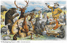
As noted by Haines, many times a hunt would be held to capture a wolf that had caused considerable damage. Two versions of the wolf hunt, described as one of the last to be held in Sussex County, have survived in written format. And although they vary slightly, they do provide an idea of how the wolf hunts took place so many years ago. The hero, in both accounts places "Buckey" (Thomas) DeKay as the main character, with the estimated guess of taking place in the early winter of 1807, with David Strait credited as the narrator.
Here's one version of the story. "An old she wolf for some years had committed many depredations, killing the farmers' sheep and even young cattle in many sections, and had become so wary as to avoid all traps that had been set for its capture. These depredations had become more and more frequent, first in the Sparta mountain, next night in the Hamburgh or Wawayanda mountains.
"The wolf had killed a number of sheep for William Headley, a brother-in-law of David Strait, at Milton. As there was a good tracking snow, Strait and Headley and several other of the neighbors organized that morning with a determination that now that old wolf must die for the many misdeeds she had done.
"She had been tracked through the mountain to Stockholm, and from thence to Canisteer, and by a long roundabout way to Vernon, where that night it had killed some sheep at 'Buckey' DeKay's. The party reached there soon after the wolf had committed the bloody act, in the early morning, having traveled day and night. When the extent of the old wolf's work elsewhere was made known to Mr. DeKay he demanded a rest and provided a bountiful breakfast for the hunting party.
"In the meantime he organized a new party with hounds and muskets, who joined with the others, and followed in pursuit of the wolf. The wolf was overtaken about noon and shot at but managed to escape, and it was not until late in the afternoon that it was finally surrounded at Beaver Dam, between Snufftown and Franklin. The hounds there closed in upon her; but many of them were killed in short order. It was here that 'Buckey' DeKay rushed in upon the conflict between the hounds and wolf, and with one well-directed blow upon the head of the wolf, killed it with his musket, and the hounds were released from their great chase.
"A bounty of $100 had been offered for the wolf, dead or alive, so its carcass was taken to the tavern at Snufftown, 'Buckey' placed the wolf carcass in an upright position, put a pipe in his mouth, and then treated everybody to whiskey. A general time of rejoicing was held and the wolf was kept on exhibition all night and everyone went to see it."
-------------------------------------------------------------------------

How to Build a Forgotten(NYC and surrounding envrions) Landscape from the Ground Up

The science behind the Welikia Hear Welikia pronounced (and Mannahatta) Project is landscape ecology. Landscape ecology is the study of how different ecosystems (e.g. forests, wetlands, streams, etc.) combine together to create habitat for plants and animals. The Wildlife Conservation Society uses landscape ecology to understand how to conserve wildlife and wild places, especially as many of the changes people make to the landscape (e.g. building roads, clearing land for agriculture, constructing cities) affect wildlife species. Our goal in the Welikia Project Hear Welikia pronounced is to build a digital version of New York City’s original ecological landscape, layer by layer, literally “from the ground up,” starting with geology, soils, topography, then streams, springs, ponds, wetlands, etc., eventually working up to species of plants and animals (including people.)

Data from Many Sources

To make this happen, we collected data from many sources. We started with historical maps which described the original features of city. To those we added information from soil surveys, tree rings, descriptions of plant life and animal life, historical accounts, even field surveys from today. For Mannahatta, we “georeferenced” all this information to a single base map, 1782 British Headquarters map from The National Archives in the United Kingdom, and created a geographic information system (GIS) database, in this case, the most complete description of a landscape ever attempted.  For the other boroughs, we will need to use a combination of maps from the 18th and 19th centuries to carefully reconstruct the forgotten landscape.

Starting from Scratch

The process of layering and analyzing spatial data is not, in and of itself, new. Many different fields use geographic information to answer questions in business, government and science.  The challenge in recreating Mannahatta, or Welikia writ large, is that none of the data layers existed prior to our work. No one alive today knows where the streams flowed in 1609 or where the bears lived or where the oak-hickory forest grew, and the native Lenape people who would have known these things left no maps behind. In other words, we had to start “from scratch.”


Bernard Ratzer, “Plan of the city of New York in North America: Surveyed in the years 1766 & 1767,” published January 12, 1776

The Lionel Pincus and Princess Firyal Map Division, The New York Public Library, Astor, Lenox and Tilden Foundations
This map, by British army officer Bernard Ratzer, is the most accurate depiction of New York in its late colonial days. At the southern tip of Manhattan are the narrow, crooked streets of Dutch and English New York. Both in the colonial town and beyond, Ratzer captured the island’s varied topography: hills and valleys; meadows, cultivated fields, and woods; ponds, streams, and swamps; and roads radiating northward along routes that started, in many cases, as native pathways.
The beginnings of order—not imposed by plan but conceived by private owners—are evident. Some owners of large properties carved their land into small grids, each abutting another at a different angle. For the most part, property owners opened streets as they saw fit, with little municipal regulation. GK


Our starting point to reconstruct Mannahatta was geolocating the 18th century British Headquarters Map to the modern street grid of New York.  We found over 200 control points where we could locate features on the map (e.g. streams, hills, ponds) to their current locations.  The final rectification was accomplished with an error of approximately 40 meters, or about half an uptown block in midtown.  Georeferencing the British Headquarters Map with this level of accuracy means that all data layers derived from it will also be that spatially accurate, allowing us to estimate the distribution of ecological features block by block across the city.  The result is a testament to the workmanship of the British military cartographers who created the map.
For the rest of the city, it won’t be so easy, because we won’t have only one map to work with.  Rather we will need to work even harder to synthesize information from many different sources into one composite base map to work with.  Fortunately though because development of the rest of the city (Brooklyn partly excepted) proceeded later in time than Manhattan, we can use maps through most of the 19th century to detect old streams, hills and shorelines that have since been erased by development

The Physical Landscape

The complex topography of the “Island of Many Hills” created the basis for over 55 different ecological communities for plants and animals and is an important factor behind Mannahatta’s original biodiversity.
The non-living, physical environment (the soils, waters, hills, and climate) can be thought of as the stage on which the ecological play is acted. Our next objective was to reconstruct these factors; an interesting exercise in itself, especially as these physical factors have been so transformed in the intervening centuries. 


Mannahatta once had 570+ hills, more than 60 miles of streams, over 20 ponds, and over 300 springs. The rest of the city had many more.  Sandy beaches stretched from the tip of Manhattan to past 42nd Street on the Hudson River shore. And beyond the shore was the vibrant, dynamic tidal estuary, with complex currents, sedimentary pattterns, and the influence of the Hudson River. Together these physical factors made for a stage as interesting as anything on Broadway today.

The Biological Landscape: Ecological Neighborhoods

Over the physical landscape, we mapped the biological landscape of ecological communities. Ecological communities are regularly occurring collections of plants and animals, like forests or wetlands; they can be thought of as “ecological neighborhoods.” Where Manhattan has the Upper West Side and Tribeca today, Mannahatta once had “coastal oak-pine forest” and “red maple swamps.” We used a system of ecological communities for New York State developed by the New York State Natural Heritage Program. Why an ecological community occurs where it does is a matter of the physical conditions of the site plus the interaction of disturbance processes like fire, windthrows, freezing, and habitat change caused by people or other animals (e.g. beavers). 


Taken together, we estimate the Mannahatta once had 55 different ecological community types. This wealth of different communities in such a narrow space in large part explains the extraordinary biodiversity of the island.  We expect that similar patterns enabled the biodiversity characteristic of the other boroughs as well, with important differences in the different parts of the city.

Mannahatta’s Abundant Wildlife

If the physical landscape sets the stage, and the ecological communities are the setting in which the play is acted, the ecological actors are the species. Through a long process of compiling historical and modern sources and consulting with scientists from many disciplines, we developed a species list for Manhattan.

Eastern Wolf


 We can not be certain of exactly what species were once on the island, so we describe different species by their probability of occurance: likely, probable, possible and remotely possible. In total, our research leads us to conclude that just over 1000 species of plants and vertebrate animals (24 species of mammals, 233 birds, 32 reptiles and amphibians, 85 fish, and 627 species of plants, and unknown numbers of fungi, lichens, mosses, insects, shellfish and other invertebrates) once occurred on Mannahatta. These likely wildlife included wolves, black bears, mountain lions, beavers, passenger pigeons, heath hens, timber rattlesnakes, tree frogs, bog turtles and over 30 species of orchids and 70 species of trees.

We expect but don’t know yet that the biological abundance of Welikia Bronx, Queens, Brooklyn and Staten Island will be greater than Manhattan’s.  We use similar techniques as for Mannahatta, but tailor them to these other four boroughs, producing borough specific species lists for the entire city.