Visitor Counter

hitwebcounter web counter
Visitors Since Blog Created in March 2010

Click Below to:

Add Blog to Favorites

Coyotes-Wolves-Cougars.blogspot.com

Grizzly bears, black bears, wolves, coyotes, cougars/ mountain lions,bobcats, wolverines, lynx, foxes, fishers and martens are the suite of carnivores that originally inhabited North America after the Pleistocene extinctions. This site invites research, commentary, point/counterpoint on that suite of native animals (predator and prey) that inhabited The Americas circa 1500-at the initial point of European exploration and subsequent colonization. Landscape ecology, journal accounts of explorers and frontiersmen, genetic evaluations of museum animals, peer reviewed 20th and 21st century research on various aspects of our "Wild America" as well as subjective commentary from expert and layman alike. All of the above being revealed and discussed with the underlying goal of one day seeing our Continent rewilded.....Where big enough swaths of open space exist with connective corridors to other large forest, meadow, mountain, valley, prairie, desert and chaparral wildlands.....Thereby enabling all of our historic fauna, including man, to live in a sustainable and healthy environment. - Blogger Rick

Subscribe via email to get updates

Enter your email address:

Receive New Posting Alerts

(A Maximum of One Alert Per Day)

Sunday, May 19, 2019

Since man first came to understand that animal skins could provide all sorts of essential clothing and footwear, hides were tanned using animal brains, dung, urine, ash and smoke".........."As man came to understand how chemistry could speed up and make more profitable the tanning process, trees and other vegetable and minerals became the ingredients of choice"............"Eastern hemlock trees played a crucial role in the early hide-tanning industry"................. "In the industry’s 19th century heyday, as many as 64 tanneries were operating in the Catskill region of New York, and estimates hold that 70 million hemlock trees were harvested for their bark".............."This story played out across the Northeast and helped shape the forest that we know today"............."The Dutch built New York’s first large scale tannery in 1638 in New Amsterdam, in an area later known as “The Swamp” near the present-day Brooklyn Bridge"............."This was an ideal location because hides could be shipped in from foreign sources and water was readily available"................"The area soon became concentrated with tanneries and leather-goods manufacturers, gaining its name from the large quantities of wastewater filled with organic matter and the constant odor of curing animal hides"..............."What New York City lacked, however, were large groves of hemlock, which grew farther upriver in the Catskills, Adirondacks, New England, and Pennsylvania"..............."Coupled with rising displeasure with the horrible conditions of “The Swamp,” this led to the development of tanneries across much of the Northeast"............."Up until the last 30 years, one could travel almost any road in Pennsylvania, New York, and across New England and spot the distinctive hemlock trees peeking out of a mixed northern hardwood forest"............. "Hemlock thrived in moist areas, where it was found in almost pure stands"..........."Its dense canopy blotted out the sun and sheltered mosses and lichens, brook trout and salamanders, among other species"............"A hemlock swamp was a familiar sight to anyone who hunted deer or trekked through the woods and mountain areas"............A real shame that Hemlock has been under siege from the non-native Asian Wooly Adelgid, a sucking insect without natural enemies to neutralize it in the USA............Like the American Chestnut and American Elm, the Hemlock that created jobs, wealth and optimized biological diversity could be heading to blink-out!

https://northernwoodlands.org/articles/article/hemlock-and-hide-the-tanbark-industry-in-old-new-york

Hemlock and Hide: The Tanbark Industry in Old New York

Hemlock and Hide: The Tanbark Industry in Old New York
Courtesy of the Zadock Pratt Museum
Since the dawn of history, humans have made great use of leather. They’ve worn it, walked on it, sat on it, wrote on it. Turning animal skin into a durable product requires processing, and in primitive times, hides were tanned using animal brains, dung, urine, ash, and smoke. As our understanding of chemistry evolved, these materials were replaced by vegetable, mineral, and then nonorganic ingredients.
Today, synthetic materials have replaced leather in many shoes and boots; nylon and reinforced cotton have replaced leather in coats; and a cow hide is more likely to become gelatin than it is a saddle. All of this can make it hard to remember that at one time the manufacturing of leather goods was an economic engine sustaining many communities in the northeastern United States.


From a forestry perspective, it’s also worth remembering that eastern hemlock (Tsuga Canadensis) played a crucial role in the early hide-tanning industry. In the industry’s 19th century heyday, as many as 64 tanneries were operating in the Catskill region of New York, and estimates hold that 70 million hemlock trees were harvested for their bark. This story played out across the Northeast and helped shape the forest that we know today.
The tanning process
In colonial America, the creation of leather from animal skins was a crucial part of life. Back then, almost every farm and homestead prepared its own leather from slaughtered domestic or wild animals. With the rise of cities and the specialization of work, leather tanning quickly developed into its own industry.


The Dutch built New York’s first large scale tannery in 1638 in New Amsterdam, in an area later known as “The Swamp” near the present-day Brooklyn Bridge. This was an ideal location because hides could be shipped in from foreign sources and water was readily available. The area soon became concentrated with tanneries and leather-goods manufacturers, gaining its name from the large quantities of wastewater filled with organic matter and the constant odor of curing animal hides. What New York City lacked, however, were large groves of hemlock, which grew farther upriver in the Catskills, Adirondacks, New England, and Pennsylvania. Coupled with rising displeasure with the horrible conditions of “The Swamp,” this led to the development of tanneries across much of the Northeast.

The Wolly Adelgid sucking insect from Japan is killing our Hemlocks


In the 19th century, the process to convert animal hides into useable leather involved several steps. After the hide was taken off the animal, it was covered with salt, which simply acted as a preservative. After being shipped to a tannery, the hide was soaked in water until it was soft and any last pieces of flesh and fat were removed. Next, hides were soaked in lime for several days. The lime solution dissolved the hair and epidermis and caused the hide to swell, which opened the fiber bundles in the dermis layer for later penetration by the tanning material. After swelling, the hides were scraped, neutralized with vinegar, shaved into uniform thickness, and often split in half lengthwise for ease of handling.


At this point, the hides were ready for tanning, a process that involved soaking the hides in vats of tannic acid, a colorless – though not odorless – astringent made from plant tannins. While historically many plant species have been used to make tannic acid, hemlock bark was the preferred source of tannins in the Northeast because of its high tannin content of 10-12 percent. Tannins bind the collagen proteins in the leather, making them less water-soluble and more resistant to decomposition. Hemlock tannins give leather a distinctive, deep reddish-brown color. Other tree species, such as oak, the mainstay of the southern tanning industry, produce a lighter, yellowish-colored leather. In the early days of the industry, a hide spent about six months curing in the bark solution.
Using hemlock for tanbark
Hemlock is native to North America, forming dense stands up and down the eastern seaboard. It is often the dominant conifer along streambanks and the lower slopes of hillsides. It will grow in dense shade and is a major component of many forests, growing alongside maple, cherry, and white pine. It can be very slow growing, as in swamps, or grow rapidly in open areas with well-drained soil, where it often reaches heights of 70 to 100 feet. Hemlock trees can live for over 250 years, or in very rare cases, over 800 years

.
Nothing quite like a Hemlock grove in a northeastern forest


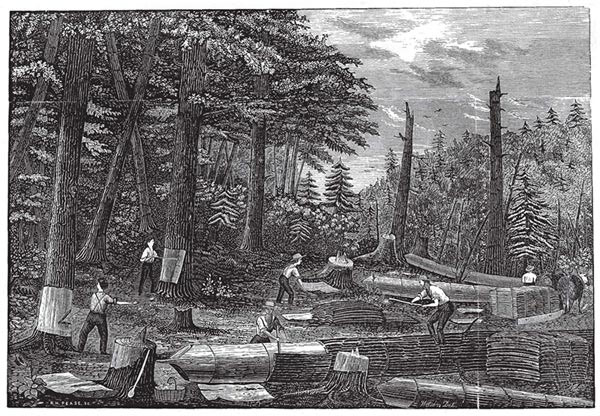
Early tanbark harvesters obtained hemlock bark in two relatively straightforward ways. Some girdled trees in the spring when the bark was loose, or “slipping,” then returned later to harvest the loosened bark “on the stump” – an act that left gleaming, barkless trees beneath the dark hemlock canopy. The more common method was to cut down the tree and then peel the bark off as far as practicable, cutting it into four-foot strips. The tree’s trunk was sometimes sawn into boards, but since hemlock is inferior to white pine for building purposes, lots of wood was left to rot in the forest. The bark was the only desired product.
After the bark was removed, it was placed on the ground with the inner, or flesh, side facing up to hasten drying and prevent formation of mold. Bark was then stacked in large piles off the ground for further drying and to await transport to the tannery. Shipping long distance in the 1800s was costly. Bark was heavy and bulky and had to be hand-loaded onto wagons or sleds pulled by horses to the tannery. In contrast, salted hides were lighter and easier to maneuver, so the hides were, in effect, brought to the hemlock, and tanneries were built close to hemlock stands.


At the tannery, conveniently sited on rivers or lakes, the bark was ground or shredded and placed in a series of hot-water filled tubs. Using a passive method, it took about four days for the tannins to leach out of the bark – steam infusions halved the time. The resulting tanning liquor was then circulated through the tanning vats in increasingly acidic solutions. Spent bark was dried and used for fuel to heat the vats.
The rise of tanneries
In the mid 1800s, fortunes were made and lost as entrepreneurs took advantage of the lucrative trade in leather. Tanneries spurred the development of communities, some of which still exist today. William Edwards was the first large-scale tanner in the Catskills. Raised in Massachusetts, where he had made and lost several fortunes in the tanning business, Edwards built a tannery in 1817 on the Schoharie Kill, at what is now the village of Hunter. Business was good, but Edwards expanded too quickly and took on too much debt. In 1839, a mere 20 years after starting, Edwards was once again in dire straits, filing for bankruptcy and closing the plant. In spite of his flamboyant behavior, he did bring several mechanical innovations into the industry, including a hide mill that was used to soften hides and a roller mill that was used for finishing sole leather.
Soon, other towns in the Catskills developed around the industry. Tannersville, today a popular vacation spot, was originally a home for many of the immigrant settlers who found work harvesting hemlock and working in the local tanneries. Rufus Palen constructed a tannery at the present day Palenville. Zadock Pratt established the largest tannery in the Catskills, and the town of Prattsville survives today, though the tannery lasted only 20 years (1825-1845). During that short time, about 2,000 people lived in Prattsville and were employed at Pratt’s tannery. In 1868, an estimated two million hides were tanned in Sullivan, Greene, and Delaware counties.


The local forests soon felt the effect of the tanbark rush. Hemlock stands were quickly cleared, bark stripped, and most of the wood left to rot. Historical texts state that two men could fell trees and peel two or three cords of hemlock bark per day. Bob Steuding, in his book The Heart of the Catskills, estimates that in its 20-year history, the Pratt tannery alone used 100,000 cords of hemlock bark from an estimated 400,000 trees.
When the easily accessible hemlock stands in the Catskills were exhausted, tanners looked to the Adirondack foothills for further supplies. Here, water was plentiful, and the Erie Canal and emerging railroads facilitated the shipment of both hides and leather. In wet areas, hemlock logs were used to make plank roads on which a horse could pull the heavy wagons or winter sleds loaded with bark. Similar situations existed in New England, where early tanneries near the seacoast gave way to newer ones farther up into the mountains. In all areas, communities sprang up around the tanneries. In Hides, Hemlocks and Adirondack History, Barbara McMartin wrote that the Adirondack region had 153 tanneries in 1850. By 1880, the number had shrunk to 112, of which roughly half were also large manufacturers of finished leather goods. Johnstown and Gloversville still retain some of this leather manufacturing, although the tanneries have long since disappeared. Tanneries operated in almost every county in northern New York. Major concentrations could be found along the Black River and West Canada Creek in Warren and Saratoga Counties and as far north as Essex County.


The Wolly Adelgid that kills Hemlocks


Life in a tannery town was tough. The work was hard manual labor. Living next to a tannery meant the constant stench of curing leather and stagnant pools of waste material. Streams became heavily polluted as tanning liquors, lime solutions, flesh, and hair were discharged directly into them. Hillsides were stripped of hemlock. On the other hand, the tanneries provided a livelihood, often for immigrants, and gave local farmers a market for the hides of slaughtered animals. Some of the tannery workers owned farms and worked in the tanneries part time or seasonally. Others lived in boardinghouses at the tanneries, where they worked 12-hour days with only Sundays off. Besides the men directly employed at the mill, the industry indirectly employed many others, including the bark peelers, who sold their bark by the cord or contracted their labor by the day. The bark peelers would set up camps in the forest during the spring peeling season and strip trees from dawn until dusk.
An industry in decline
By the 1900s, the tanning industry was changing and people’s attitudes towards heavily polluted streams and obnoxious odors were also changing. In the coming years, many factors would combine to spell the end of the hemlock tanning industry. The depletion of accessible hemlock was an important one. This was overshadowed, however, by better transportation by rail and highway that lowered the cost of shipping bark and freed tanneries from locating close to a bark supply. Beef farming also consolidated and moved west, which increased shipping costs for hides. Tanneries began to import bark from tropical species, yielding leathers with different colors and properties that suited the changing tastes of consumers. Chromium, oils, aldehydes, and synthetics began to replace plant tannins, and these chemical processes tanned hides much more quickly than the tree-bark method. The mechanization of manufacturing placed leather tanning, with its heavy dependence on manuallabor, at a disadvantage. The economic conditions of the late 1800s were another reason for the demise of the tanning industry in the Northeast. Depressions and skepticism had set in, capital was harder to obtain, and businesses were closing. Although some plants in New Jersey used bark until the 1920s, the hemlock bark-tanning industry had largely ended by the beginning of the 20th century.


And what happened to the hemlock? Early writers saw denuded hillsides, with rotting hemlock trees stripped of their bark, and bitterly lamented the destruction of majestic hemlock forests that had stood for hundreds of years. Their fear fed into the popular view, at the beginning of the 20th century, that the country had lost its forests forever. Indeed, hemlock forests that were ruthlessly clearcut did not regenerate quickly. Many tanneries left eroded soil, silted streams, and sometimes piles of hemlock bark rotting in the woods. On rare occasions, one can still see the remains of these abandoned bark piles.
Despite all this, hemlock came back. Today hemlock timber is harvested for lumber and wood pulp. Although the wood is difficult to finish, in a rough state it makes good construction timber. Hemlock’s use for wood pulp is a fairly recent development, but Finch Paper Co. in Glens Falls, New York, has based its entire paper-making operations on hemlock, which is much cheaper than other species and produces paper of good quality. Hemlock from New York and New England is also going to Canada for both pulpwood and lumber.
Today, one can travel almost any road in Pennsylvania, New York, and across New England and spot the distinctive hemlock trees peeking out of a mixed northern hardwood forest. Hemlock thrives in moist areas, where it’s found in almost pure stands – its dense canopy blotting out the sun and sheltering mosses and lichens, brook trout and salamanders, among other species. A hemlock swamp is a familiar sight to anyone who has hunted deer or trekked through our woods and mountain areas. That the hemlock has returned is a testament to the inherent biological ability of the species to survive.
Hugh O. Canham is emeritus professor of forest and resource economics at the SUNY college of Environmental Science and Forestry. He lives in North Syracuse, New York.
-----------------------------------------------------------------------------

Hemlock Woolly Adelgid

Hemlock woolly adelgid nymphs settled at the base of hemlock needles.  Note that these young adelgids have just begun to form the white wool around the edges.The hemlock woolly adelgid, Adelges tsugae(HWA), a tiny sap-sucking insect related to aphids, is causing widespread death and decline of hemlock trees in the eastern United States. This species, native to Asia and the Pacific Northwest, was first noted in the eastern United States in 1951 in a park in Richmond, VA. The genotype present in eastern North America originated in Japan and was probably introduced unintentionally with ornamental Japanese hemlocks. It initially spread slowly until the late 1980s when it reached natural forests and began to kill trees by the thousands. It has since spread into at least 17 states from the Smoky Mountains to southern Maine. The HWA has few natural enemies in eastern North America, no parasitoids worldwide, and our native eastern hemlock species are neither resistant to nor tolerant of adelgid feeding. Without these natural defenses, the adelgid poses a very serious threat to the sustainability of eastern hemlocks.
Research on the HWA by scientists at the Northern Research Station and their cooperators is focused on outlining the scope of the problem and identifying management options. Specifically, work on the HWA falls into four inter-related areas.
  • Risk, Detection, and Spread: Understanding if, when, and how the adelgid is likely to infest new forests provides critical information for managers as they work to identify areas that are at high riskand allows managers to prioritize control efforts based on where and when those efforts will be most effective.
  • Biology and Ecology: Work is underway to improve our understanding of the biology of the HWA, including its life history, reproduction, and ecological role.  The data can provide the basis for evaluating where, when, and under what conditions the adelgid is likely to cause damage, as well as what basic mechanisms may act to control populations. 
  • Control and Management: Data collected by evaluating adelgid biology, ecology, landscape risk, and spread are used to develop control and management techniques.  These techniques include the development of resistance to the adelgid in our native eastern and Carolina hemlocks.  Control and management efforts also include the development of appropriate natural enemies as biological controls.  Although chemical controls, such as the use of systemic insecticides and horticultural oil, have proven effective in controlling adelgids in yards, gardens, and parks, the cost, effort, and environmental consequences associated with these chemicals make them inappropriate for forests at the landscape scale.
  • Effects and ImpactsAssociated with efforts to control and manage the adelgid are efforts to understand the nature and magnitude of adelgid impacts on eastern forests.  Current work includes efforts to identify those impacts both directly through the loss of hemlock species and indirectly through changes in the structure and biodiversity of eastern forests. This information can be used to evaluate the severity and nature of the threat to eastern forests posed by the HWA.             

Thursday, May 16, 2019

In the USA east, Mountain Caribou went extinct in the late 19th century.................In the USA west, the last herd of these iconic browsers are now also functionally extinct.............Known as the Selkirk herd(Norther Washington State Mountians into southern British Columbia, Canada),), the final two remaining Caribou were rounded up over the past two years and transplanted into what is known as the North Columbia,British Columbia herd.................."This is the 11th hour for British Columbia's southern mountain caribou that had also occupied northern Washington State"............ "At the turn of the 20th century, scientists believe, there were between 30,000 and 40,000 caribou in BC"................"As of 2014, the federal government estimated the number of caribou at 5,800, in 38 subpopulations distributed among three groups: Northern, Central, and Southern"............"The Southern Group, which traditionally ranges in the Columbia Mountains from Revelstoke to the United States border, is globally unique"............"These deep-snow specialists are the only subspecies of caribou or reindeer that in winter subsist entirely on arboreal lichen found in old-growth forests"...................."caribou specialists have been put in the unenviable position of supporting the targeted killing of wolves and other predators to protect mountain caribou"............."However they all agree that predator culls are a stop-gap measure that will fail unless core caribou habitat is restored and protected"................ "Biologists are just starting to understand the importance of what he calls “matrix habitat,” or the land base around core habitat where forest practices can disrupt the predator-prey balance further threatening caribou"............... “Mountain caribou are in a very difficult situation because they require large areas of habitat and there are manyhuman-centric, competing interests that are incompatible with caribou"

https://www.google.com/url?rct=j&sa=t&url=https://www.sierraclub.org/sierra/can-canada-save-mountain-caribou-it-s-too-late&ct=ga&cd=CAEYACoTNTQxNzk1NTEzMzg3MjAzNjc3MDIaZWM0NDQ0NDY0YzhiNmFhMTpjb206ZW46VVM&usg=AFQjCNEETFRkaGAzERWz7MN_O4eSFXYS

Can Canada Save the Mountain Caribou Before It’s Too Late?

The iconic animal is at risk of extinction

BY Andrew Findlay | MAY 15 2019


On a frigid day last January, government biologist Leo DeGroot led a team deep into the southern Selkirk Mountains of British Columbia on a rescue mission. Between 2017 and 2018, the mountain caribou herd native to these rugged mountains had dwindled to just two cows. DeGroot and his team set out to save the animals, part of a two-stage plan that included capturing four others—two bulls and two cows—from the equally imperiled South Purcell herd, which had experienced a precipitous drop from 60 animals in the early 1990s to just four last year. 
A LONE BULL IN THE SOUTH SELKIRK HERD DODGES TRAFFIC ON BC'S HIGHWAY 3 AT KOOTENAY PASS. | PHOTOS BY WILDSIGHT


“These animals had no future. The herds are extirpated, functionally extinct,” DeGroot said from his office in Nelson, on the west arm of Kootenay Lake between the Selkirk and Purcell Mountains. 
From mid-January to mid-February, the biologist organized two trips to truck a total of five sedated mountain caribou five hours to a staging area 60 miles north of the city of Revelstoke. From there, they used a helicopter to sling the animals across Lake Revelstoke to a maternity pen—a fenced enclosure where females and their newborn calves are kept safe from predators and given a fighting chance during the vulnerable first few months after birth.
On April 2, after three months in the maternity pen, the five transplanted caribou were released along with a cow and her calf that belong to the North Columbia herd, a relatively robust group of 150 animals that range between the northern Selkirk and Monashee Mountains surrounding the maternity pen. 
“We were hoping they would follow this experienced cow, and it seemed to work,” DeGroot says.
CARIBOU COW IN THE DOOMED SOUTH SELKIRK HERD.


It's a small success in one of BC's most pressing conservation challenges. 
This is the 11th hour for British Columbia's southern mountain caribou. At the turn of the 20th century, scientists believe, there were between 30,000 and 40,000 caribou (Rangifer tarandus caribou) in BC. As of 2014, the federal government estimated the number of caribou at 5,800, in 38 subpopulations distributed among three groups: Northern, Central, and Southern. 
The Southern Group, which traditionally ranges in the Columbia Mountains from Revelstoke to the United States border, is globally unique. These deep-snow specialists are the only subspecies of caribou or reindeer that in winter subsist entirely on arboreal lichen found in old-growth forests.  
Yet all of the isolated population units in the Southern Group are decreasing or extirpated. Since 2007, when BC launched the Mountain Caribou Recovery Implementation Plan, the province, feds, and industry have spent more than $12 million on a range of caribou conservation efforts, including publicly unpopular targeted predator culls, maternal penning, wolf collaring, and developing special operating guidelines for commercial and noncommercial regulation.

 More than 200,000 hectares inside and outside of national and provincial parks have been set aside as core mountain caribou habitat. However, MCRIP has fallen far short of the goal to boost the Southern Group total population to 2,500 animals. Current estimates put the population at 1,200. By most accounts, it's been a failure. That's why in May 2018, Canada's minister of environment and climate change, Catherine McKenna, put BC on notice: Do more to save this species or Ottawa will step in to impose conservation measures. 

No politician wants an iconic species that graces the Canadian 25-cent coin to go extinct on their watch. Loss of critical, or core, habitat due to logging, oil and gas development, and other resource industries is largely responsible for the animal's decline. Human-caused landscape alteration has also resulted in a cascade of impacts that have upset the natural predator-prey balance in some areas, making the slow-reproducing caribou even more vulnerable. Logging gives rise to the growth of young trees and underbrush that attracts browsing animals like white-tailed deer and moose in large numbers. This in turn lure predators like wolves and cougar into caribou habitat.

FIELD TECHNICIAN CAM THOMPSON BEGINNING A NECROPSY ON A COLLARED SOUTH PURCELL CARIBOU LIKELY KILLED BY AN AVALANCHE IN THE EARLY 2000S. INCREASED PRESSURE FROM SNOWMOBILES CAN FORCE CARIBOU FROM CRITICAL WINTER HABITAT INTO MORE-AVALANCHE-PRONE AREAS, OR INTO AREAS WITH LOWER-QUALITY WINTER FOOD.


Canada's Species at Risk Act lists BC's southern caribou as threatened. The legislation enables the federal government to issue an emergency order and make decisions about resource extraction, tourism, and other activities that are normally a provincial responsibility if it decides provincial efforts to recover an endangered species are falling short. (The Canadian government has issued an emergency order only twice before, in 2014 to protect the sage grouse and in 2016 for the western chorus frog.) McKenna has given a deadline of this summer for the province to develop a so-called Section 11 conservation agreement
“This is an important species to the federal government,” says Robert Serrouya, a Revelstoke-based University of Alberta biologist who has researched large mammal ecology for two decades and is currently director of the Caribou Monitoring Unit. “And it's a very complex conservation problem.”
DeGroot, Serrouya, and other caribou specialists have been put in the unenviable position of supporting the targeted killing of wolves and other predators to protect mountain caribou. However they all agree that predator culls are a stop-gap measure that will fail unless core caribou habitat is restored and protected. According to DeGroot, biologists are just starting to understand the importance of what he calls “matrix habitat,” or the land base around core habitat where forest practices can disrupt the predator-prey balance further threatening caribou.
“Mountain caribou are in a very difficult situation because they require large areas of habitat and there are many competing interests that are incompatible with caribou,” DeGroot says. 
This past winter, the BC and federal governments released two draft conservation documents that remain open to public comment until the end of May. The first is with the West Moberly and Saulteau First Nations, two bands with territories north of Prince George that have been working independently to recover the Klinse-za herd using a combination of maternity penning, hunting bans, and habitat restoration. The government agreement proposes additional caribou conservation measures in West Moberly and Saulteau territories, including a reduction in forest harvesting by 300,000 cubic meters annually (one cubic meter roughly equals one telephone pole).  
The second document is a draft caribou conservation agreement between the feds and province for the rest of BC's caribou herds. It is a wide-ranging agreement that covers everything from restricting motorized vehicle access in winter caribou habitat and reviewing hunting regulations to reducing primary prey in important caribou habitat, purchasing private land for habitat protection, and extending predator control into other areas. Sean Fraser, parliamentary secretary to the federal minister of environment and climate change, admits that both draft agreements have come under fire from community and industry leaders worried about economic impacts and restriction to the land base for recreation. At the same time, he says, there is widespread acknowledgment that mountain caribou are teetering on the edge.
“It’s clear to all parties involved that if we don’t act now, we could lose the caribou forever,” Fraser says. “Decades of inaction by successive provincial governments have resulted in the critical situation we face today. The government of Canada is required by law to step in to protect species at risk if other measures taken by the responsible province are not effective.”
Eddie Petryshen is conservation coordinator for Wildsight, an environmental group based in the East Kootenays. He calls mountain caribou an indicator species and says their decline and extirpation in southern BC has mirrored the destruction of the inland temperate forest. He's hopeful that the new conservation agreement spells better times ahead for mountain caribou, but only if discussions translate into real action.
“We support the conservation agreement in that at least the feds and province are working together. But we need action. The rubber will hit the road when they start developing the individual herd plans,” Petryshen says, adding that this process is supposed to be completed by 2020. 
Still for some herds, 2020 might be too late. Back in Nelson, Leo DeGroot says it's hard to sidestep the fact that government neglect has brought caribou to this critical juncture. Rampant hunting from the time of European contact in the mid 1800s to the mid 1900s hit the animal hard. Industrial logging went to work on caribou habitat. By the time BC started studying and accurately counting caribou in the mountains that surround his home in Nelson, DeGroot says, they were already shoehorned into isolated herds.
“I'd like to think that we have the political and public will to save mountain caribou,” DeGroot says. “I've been working with this animal for almost 20 years.”

Monday, May 13, 2019

So what is the purpose of Scales and Lateral Lines on Fish?................Scales are a type of "Cloaking Device" to make fish almost invisible to predators, a type of protective armor and additional "gear" to assist them propelling themselves through rough currents................"Note that fish are like delicate sensing devices, like a swimming antenna"..........."Their lateral line is a system of sensors and channels that run across the fishes’ head and body, controlled by the arrangement of the scales and the microscopic hairs between them that respond to flow, turning mechanical motion into electric signals"............."Fish are said to be able to detect earthquakes before the most sensitive of human inventions"..............."It’s the lateral line that shapes fish behavior, whether that fish is an ambush predator like northern pike or a fish like American shad that has to navigate fishways, falls, changeable flows from dams, and hot water plumes from nuclear power plants to spawn"..............."Further, A lateral line is a sense organ fish use to detect movement and vibration in the surrounding water"............... "They use it to detect depth/water pressure, prey, pretators, sense current movement and orientation in the current, as well as to avoid collisions"............... "It essentially is a form of eyes, ears and sensory feelings combined into one organ"..................... "All fish have some form of a lateral line, some having a more developed one then others"............. "Lateral lines are usually visible as faint lines running lengthwise down each side, from the vicinity of the gill covers to the base of the tail"................ "Sometimes parts of the lateral organ are modified into electroreceptors, which are organs used to detect electrical impulses"................"It is possible that vertebrates, such as sharks, use the lateral organs to detect magnetic fields as well"


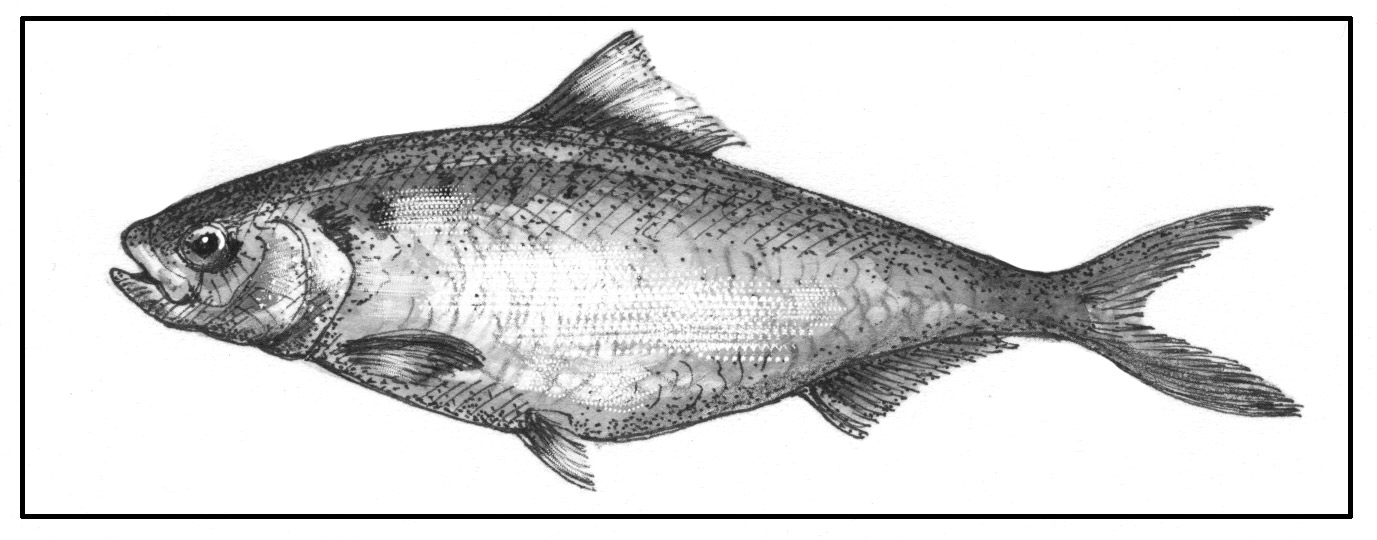
Fish Scales and the American Shad

Fish Scales and the American Shad
Illustration by Adelaide Tyrol
It’s tempting to simply view fish scales as armor, but there’s more to them than that. They provide camouflage; they also play a role in locomotion. For scientists working on the recovery of American Shad in the Connecticut River, scales provide a record of a fish’s life history and a way to measure the success of restoration efforts.
American shad is our largest river herring. The males, called bucks, run up to six pounds. The females, or roe shad, up to four. Like their cousins alewife and blue-backed herring, shad are anadromous, spending most of the year in the ocean, then running up fresh water rivers like the Connecticut in spring to spawn.
Shad have large silver scales – all the river herring do. The silver reflects the surrounding environment and allows the schooling fish to become nearly invisible to predators, sort of like that invisible car in the James Bond film. A quick shift in direction becomes a game of “Now you see us, now you don’t.”


For migratory fish like the river herring, the less obvious but no less important role of scales is their function as part of a fish’s lateral line system. A fish is a delicate sensing device, like a swimming antenna. The lateral line is a system of sensors and channels that run across the fishes’ head and body, controlled by the arrangement of the scales and the microscopic hairs between them that respond to flow, turning mechanical motion into electric signals. Fish are said to be able to detect earthquakes before the most sensitive of human inventions. It’s the lateral line that shapes fish behavior, whether that fish is an ambush predator like northern pike or a fish like American shad that has to navigate fishways, falls, changeable flows from dams, and hot water plumes from nuclear power plants to spawn.  
Shad seem made for long distance travel. The 18- to 22-inch body is ovoid in profile, a small head with an expansive back and wide sides that slim down to a narrow, deeply forked tail. Shad: one big muscle with just enough room for the stores of fat needed to make the spawning journey.

A fish scale is a small rigid plate that grows out of the skin of a fish. The skin of most fishes is covered with these protective scales, which can also provide effective camouflage through the use of reflection and colouration, as well as possible hydrodynamic advantages


There’s beauty in that economy. Scale patterns have been described as fractals: objects of “expanding symmetry.” Shad scale patterns bring to mind the art of the ancient Chinese, say from the Ming Dynasty, or a classic Zen fish you might see in an art store window. Functional beauty. You can see them migrating past the window at the Vernon Dam fish ladder, powering like pale green ghosts through the roil and bubbles on their way upstream to Bellows Falls.
Unfortunately, river herring populations across their northeastern range have been severely reduced. Dams, power plants, and habitat loss are all factors. Only about 5-10 percent of the shad that make it as far Holyoke, Massachusetts (measured in the hundreds of thousands, but down from three to five million historically) make it to Vernon. But there’s hope. With some changes to the fishways and flows on Connecticut, we could see huge increases in river herring in the Connecticut River over the coming decades.
I spoke last summer with Ken Sprankle, a fisheries biologist with US Fish and Wildlife Service who’s in charge of protecting and restoring migratory fishes in the Connecticut River Watershed. Sprangle described analyzing about 1,300 shad in the lab annually. He records fish age by looking at otoliths – ear bones. He also looks at scales. Scale analysis shows the number of times a fish has spawned. Shad typically return to the river to spawn after only one year in salt water, Sprangle said. Since shad can live up to ten years and spawn as many times, improving return rates and expanding upstream habitat by reducing the stress of migration and mortality, in both upstream and downstream trips, could have a profoundly positive effect on shad populations.
The challenges are great for shad, particularly at Turner’s Falls, Sprangle said.  Here, the fish deal with both low-flow conditions and massive surges of water when the Northfield regenerating station discharges water. Three separate fish ladders divert shad from the stream’s natural channel into a mile-long canal, which is as far as many of them get.  
An agreement could be negotiated in the course of the dam’s relicensing process that would replace the faulty fishway at Turners Falls. Meanwhile, we’re left to imagine what a half a million shad at Bellows Falls might look like.
Tim Traver writes about fish and wildlife issues from his home in Taftsville, Vermont.

Wednesday, May 8, 2019

"Floodplain forests usually occur in the low, flood-prone areas along rivers, typically less than 20 feet above the river channel"............."They are often associated with oxbows (pools that have become separated from the river channel), temporary wetlands that dry up in summer (vernal pools), open meadows of grasses and wildflowers, and dense shrub thickets"..........."The tree species in this forest are flood-tolerant and thrive in the nutrient-rich sediments brought by floods"............"These periodic floods recycle sediment and nutrients, creating rich soil deposits".............."Floodplains create rich insect and amphibian breeding habitata"........... "In turn, the amphibians become prey for birds such as woodcock and barred owl, mammals such as mink and raccoon and reptiles such as smooth green snake and wood turtle".......... "Research in the Connecticut River region(state of Connectitcut) has shown that spring flooding thaws the soils of floodplain forests earlier than soils in surrounding areas"............"This early thaw means that insects become available to birds (as food) earlier, so birds will feed in, follow, and depend more heavily on floodplain forests than other forested habitats during the early spring migration"............."Floodplains also provide corridors that allow wildlife(black bears, coyotes, bobcats, foxes, fishers, raccoons) to move from one habitat to another, especially in urban areas where development has fragmented alternative travel routes"..............."The overhanging canopy in floodplain forests also helps maintain cool waterways in the summer, which helps species such as brook trout"............"For the beaver felling a tree, the oriole bringing a caterpillar to its young, the bear digging grubs out of a rotting log, and for people living in homes downstream, bringing back floodplain forests is certainly worth the effort"


Visiting a Floodplain Forest

Visiting a Floodplain Forest
Illustration by Adelaide Tyrol
Visiting a forest along one of our major rivers, such as the Connecticut River, in late spring, is like entering a special world. Big silver maples tower overhead, with arching branches and roots reaching deep underground. Cottonwoods up to five feet in diameter and vase-shaped American elms are scattered about. Scars on the upstream side of some tree trunks bear testament to the chunks of ice that crash through when the river floods every spring. Silt stains on the trunks and dead leaves, trash, and other debris caught in crotches of trees show the height of the floodwaters. Many trees cannot withstand flooding, but the species in this forest are flood-tolerant and thrive in the nutrient-rich sediments brought by floods.
Tall clumps of ostrich fern, their fronds resembling ostrich plumes, and dense patches of wood nettle grow out of fresh sand and silt deposited by the river. There are few shrubs, but thick grapevine ropes climb tree trunks. Birds sing and flit among the treetops. Toads trill from a depression that still holds water from the spring floods. Along the river’s edge, the roots of black willow reach over the bank and the tracks of an otter can be seen in the mud.


Floodplain forests like this were common along northeastern rivers before European settlement, the meandering green ribbons extending for miles. Now they are a rare natural community. Their fertile soils with few stones were prized for farming and easy to build on, so most floodplain forests have been cleared for agriculture and development.
The many benefits these forests provide were lost with their disappearance. Floodplain forests help prevent catastrophic flooding downstream by storing and slowing floodwaters. They filter pollutants running off farm fields and urban areas, preventing them from entering streams, thereby improving water quality. Tree roots help stabilize riverbanks, controlling erosion. The overhanging tree canopy keeps the water cooler in summer, aiding cold-water fish such as brook trout.


The rich, alluvial soils of a floodplain forest create ideal habitat for insects and amphibians, which in turn become prey for animals like woodcock, mink, raccoon, and wood turtle. Spring flooding thaws the soils of floodplain forests earlier than the soils of surrounding areas, making insects available to birds earlier. For this reason, spring migrants follow rivers and feed in floodplain forests as they journey north. Some, like the warbling vireo, northern oriole, and great crested flycatcher, stay and nest here.
In addition to clearing for agriculture and development, threats to our remaining floodplain forests include dams and invasive species. Dams alter the river’s natural flooding regime and trap nutrient-rich sediments that would normally be deposited in these forests. Run-of-the-river dams, which allow normal flow except in periods of high water, are better for floodplain forests. Invasive species such as Japanese knotweed do well in the exposed soils and abundant sunlight of floodplain forests and can outcompete native vegetation.


In recent years, watershed associations have been planting buffer strips of trees along rivers. There have also been a few encouraging initiatives to restore whole floodplain forests in the Northeast.
The Nature Conservancy has completed several such projects in Vermont. “Floodplain forests are really important natural communities that provide wildlife habitat and ecosystem services to people, but are one of our most diminished communities,” said Rose Paul, Director of Science. The Conservancy planted native, flood-tolerant trees and shrubs on 50 acres it purchased on Otter Creek in Cornwall. Over the past ten years, the trees have grown on these former agricultural fields that their owners decided were too wet to farm. Other floodplain forest species such as marsh bedstraw, willows, and dogwoods have sprouted from the natural seed bank that remained in the soil and from seeds washed in by floods. The types of trees that do well at a particular site varies with the duration of flooding, advised Paul. Silver maple, green ash, black willow, and swamp white oak are a few of the common species.


In Vermont’s Northeast Kingdom, the organization has planted disease-tolerant American elms as well as other floodplain natives at its Maidstone Bends Natural Area along the upper Connecticut River. These elms were developed by crossing eastern “survivor” elms that were naturally tolerant of Dutch elm disease to cold-hardy Vermont elms that showed a similar resistance.
For the beaver felling a tree, the oriole bringing a caterpillar to its young, the bear digging grubs out of a rotting log, and for people living in homes downstream, bringing back floodplain forests is certainly worth the effort.

Susan Shea is a naturalist, conservationist, and freelance writer who lives in Brookfield, Vermont.

Monday, May 6, 2019

"Connecting people to place from Maine to Florida is the goal of the EAST COAST GREENWAY PROJECT, an envisioned protected and continuous walking, hiking and biking route stretching 3,000 miles from Maine to Florida".............."The East Coast Greenway is designed to transform the 15 states and 450 communities it connects through active and healthy lifestyles, sustainable transportation, community engagement, climate resilience, tourism, and more"............"The nonprofit East Coast Greenway Alliance leads the development of the trail network working with hundreds of volunteers, partner organizations, and officials at the local, state, regional and national level to continue moving more of the route onto protected paths".............."In Maine, University of New England researchers have initiated the GAP TRACKS PROJECT to help facilitate the protection of swaths of southern Maine for inclusion into the Greenway"..........."Using Camera Traps, they have found the heavily human populated Nonesuch River/Scarbourough Marsh region a haven of wildlife diversity"..........."Eastern Coyotes, Red Foxes, Wood Ducks, Bobcats, Wild Turkeys, Whitetail Deer and 44 other species are thriving here"............Once installed, will this new section of trail completely displace the wildlife due to human encroachment or will it only change the behavior of wildlife without casusing population blinkouts?"


ttps://www.google.com/url?rct=j&sa=t&url=https://www.pressherald.com/%3Fp%3D1955940&ct=ga&cd=CAEYACoSMzQ2MzE3MDk5MDQ1MzE2ODkwMhoyOThkYTBiNDM3OTdhYmZiOmNvbTplbjpVUw&usg=AFQjCNEZMk3kU5LBFf4Dt0L0NUUxeovz5Q

BY DEIRDRE FLEMING; MAY 5, 2019

Wildlife thrives on candid camera along

 the Eastern Trail in Maine

UNE professor Noah Perlut will use the data to assess 

the impact of a planned 1.6-mile trail 


SCARBOROUGH — In the spring of 2017, University of New England professor Noah Perlut downloaded the first videos from a game camera he’d hung low on a tree just off the Eastern Trail near the Nonesuch River in order to record the wildlife living nearby. Later, from his office, he looked at the images the camera captured over a two-month stretch. He was surprised at the first species he observed in the video, waddling through the woods: a pair of wood ducks foraging on the forest floor. “I was predicting more common terrestrial species like gray squirrels or turkey,” Perlut said. “A relatively rare migratory duck searching for acorns surprised me. I do not think we have had any other wood ducks since.”


Two years and tens of thousands of images later, Perlut is ever more interested to learn what surprises await in the data that comes from his game-camera study. It’s scheduled to be completed in 2021.

Covering more than 3,000 acres, Scarborough Marsh is the largest contiguous salt marsh system in Maine(located in southernmost county of Maine).


The Gap Tracks Project – believed to be the first study of its kind in Maine – uses two game cameras placed around an existing section of the Eastern Trail to the south of the Nonesuch River and six cameras in the now-wild, 1.6-mile stretch of woods to the north, where the trail will be continued this fall. Perlut will continue to gather still photos and videos from the cameras after construction on the new section begins, while construction is underway, and for one year following the completion of the new section. For now, this missing section of the trail is called “the gap;” the new construction will connect the trail to the north, which winds through South Portland, with the trail to the south, which makes its way through Scarborough Marsh.

Red Fox out hunting in Winter


Once these two sections are connected, this part of the Eastern Trail will be a continuous 17-mile foot-and-bike path from South Portland to Saco. All told, the 65-mile off-road trail from South Portland to Kittery – 23 miles of which has been built – is part of the 3,000-mile East Coast Greenway, which one day will extend from Calais to Key West, Florida.

On the face of it, the Gap Tracks Project studies the effects of urban sprawl. Biologists believe that when human development encroaches on wildlife habitat, it drives wild animals into smaller, fragmented swaths of woods, fields and marshland, making it harder for wildlife to forage, mate, raise young, and generally flourish. But Perlut and other biologists aren’t certain the new section of trail will completely displace the wildlife. Perlut said it may only change the behavior of wildlife that’s already there.

Camera trap in the woods


Many wild animals in Maine, both diurnal and nocturnal, adapt to living around humans but often go undetected, said Maine Wildlife Biologist Brad Zitske. A frequent viewer of the Gap Tracks Project’s photos and videos, Zitske was amused at the photo of a coyote with “someone’s chicken” and a coyote carrying a groundhog almost half its size.

“This is as suburban as Maine gets, so this is a really cool opportunity to see what wildlife we have living in our backyards,” Zitske said. “There’s quite a suite of animals there. So much of the time as a regional biologist, my work is involved in nuisance wildlife. It’s nice to have photos of wildlife being wildlife.”

Zitske said simply informing people what animals use the marsh is useful – especially when you consider that Scarborough Marsh, the largest salt marsh in Maine, lies smack in the center of the state’s most developed area in York and Cumberland counties, home to 37 percent of the state’s 1.3 million people. According to a 2018 study by the Eastern Trail Alliance, the nonprofit that is building the Eastern Trail, more than 250,000 people used the trail last year.

Meanwhile, the game cameras have photographed turkeys, deer, skunks, coyotes, fox, bobcats and 44 other species of wildlife around the trail. Perlut gathers photos and videos from his eight cameras once a month. Sometimes there are just 40 photos on a camera, other times several thousand. The motion-detection cameras take two quick pictures after movement trips them, followed by a 10-second video.